If you spend any time watching the skies over Washington in autumn, you know the shift when it arrives. On the night of September 18, 2026, radar estimates recorded a staggering 790,500 birds crossing King County overnight, with a peak of 343,100 birds aloft at once, moving at an average of 19 mph and altitude of 3,900 ft. From the mudflats of Grays Harbor to the tidal channels of the Skagit Delta, millions of birds are working their way along the Pacific Flyway.
I’ve been out on enough early-morning field trips and quiet evening watches to feel that movement in my bones. As someone who works on AI products by day and builds the occasional birding tool on the side, I keep coming back to the same question: how do we actually protect these corridors when the birds themselves are so hard to track?
Behind the spectacle sits a hard conservation problem and a quieter technical one. How do you map the stopover sites of a 20-gram bird across a 10,000-mile journey without the tracking device itself becoming the limiting factor?
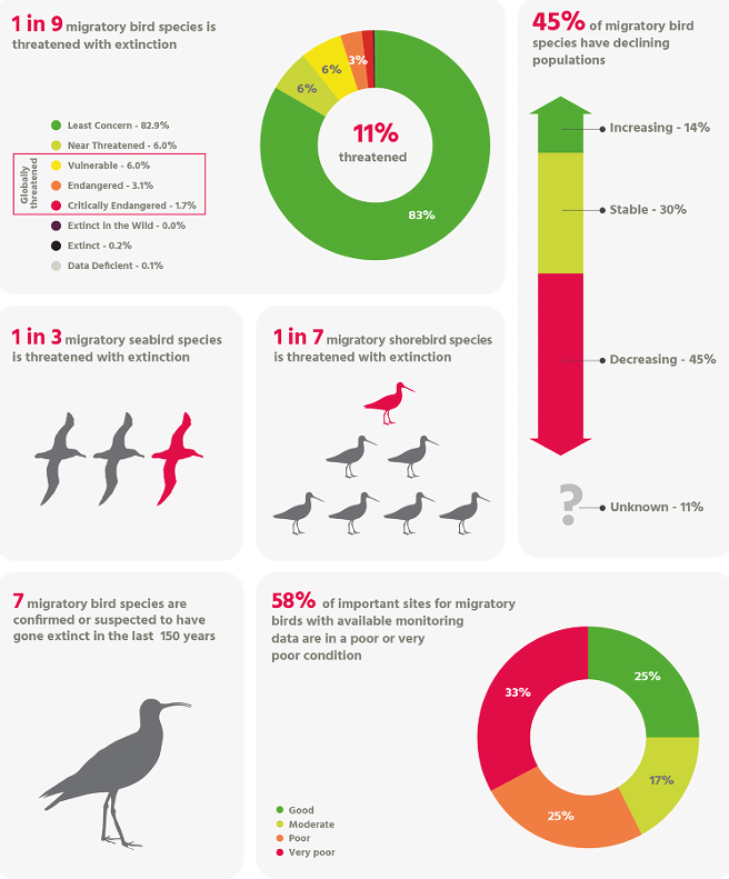
On September 11, 2026, BirdLife International released its 6th State of the World’s Birds report in Nairobi. The numbers are stark. 45% of migratory species are in decline. 1 in 9 faces global extinction risk. Shorebirds and seabirds tied to coastal estuaries are falling fastest with 54% dropping rapidly, and 58% of monitored Important Bird and Biodiversity Areas are rated in poor or very poor condition. These figures sit on top of the 2019 Science study that documented the loss of 2.9 billion breeding adult birds in North America since 1970. Living in Washington, where so many of these species still depend on a handful of critical estuaries, those statistics feel close to home. Isolated habitat protection is no longer enough. We need to understand connectivity across the full annual cycle, meter by meter.
That is where the technology has had to change.
The Constraint That Forced a New Architecture
The fundamental limit in avian bio-logging is mass. A transmitter cannot exceed roughly 3–5 percent of the bird’s body weight, which means tags for small songbirds and shorebirds must weigh less than a gram. Ten years ago the dominant approach was essentially direct-to-cloud. Birds carried relatively heavy Platform Transmitter Terminals that broadcast high-power signals all the way to satellites. The power cost restricted the technology almost entirely to large raptors.
The architecture has inverted. Because radio transmission is the most energy-expensive action a device can take, the burden moved from the animal to the infrastructure on the ground. Lightweight digital tags now only need to emit short, low-power pulses. A distributed mesh of terrestrial receivers does the heavy lifting.
That mesh is the Motus Wildlife Tracking System. Organizations such as the American Bird Conservancy are coordinating its expansion across the United States specifically to support research on declining species like the Red Knot and Wood Thrush. At the same time, the tags themselves have evolved. Early units relied on primary lithium cells and fixed sleep timers. Newer modular designs, some open-source, such as the WildFi bio-logging framework, incorporate fingernail-sized solar cells and hybrid energy storage. Intelligent duty-cycling software keeps the devices in deep sleep most of the time, giving sub-gram tags a near-indefinite operational life under good conditions.
The practical result looks like this:
[ Nanotag (166.380 / 434 MHz) ] ── (Radio Pulse) ──> [ Directional Yagi Array ] ──> [ Receiver Master Node ] ──> [ Centralized Motus DB ]
A bird carries a coded nanotag weighing between 0.2 and 1.0 grams. The tag emits brief pulses at standardized VHF or UHF frequencies. Ground stations with directional or omnidirectional antennas listen continuously, logging timestamp, tag ID, and signal strength whenever a bird passes within range, often 12 to 19 kilometers. Algorithms then reconstruct bearing, ground speed, and stopover duration. More than 50,000 individual animals have been tagged across 34 countries, turning what used to be sparse recovery data into continuous, multi-station trajectories.
If you’re new to Motus, these two short videos give a clear sense of how the system actually works in the field:
What is MotusA Decade of Change in Practice
From a systems perspective the field has moved from simple logging to something closer to a real-time, edge-to-cloud network. The differences are substantial:
| Technical Pillar | 2016 Baseline | 2026 Reality |
|---|---|---|
| Power & Energy | Non-rechargeable micro-batteries and hardcoded timers. GPS tags often weighed 10–15 g, usable only on large raptors. | Micro-solar cells and hybrid storage on tags under 1 g, with dynamic harvesting that can keep devices alive indefinitely under good light. |
| System Architecture | High-power satellite transmitters (Argos-style). Sparse, expensive pings. | Terrestrial receiver networks. The tag only needs to whisper low-power bursts; the ground infrastructure carries the rest of the load. |
| On-Device Intelligence | Dumb loggers that stored raw files until the bird was recaptured. | TinyML models running on microcontrollers. Tags classify events locally and send compact event codes instead of raw streams. |
| Data Use | Post-season GIS analysis of historical tracks. | Continuous telemetry feeding spatio-temporal models that can trigger conservation actions while birds are still moving. |
Edge Intelligence on the Wing
The power problem was only the first bottleneck. Once tags could stay alive longer, bandwidth became the new constraint. Streaming continuous high-frequency accelerometer or audio data still drains a micro-battery in hours. The practical solution has been to push more intelligence onto the device itself.
The underlying engineering principle is straightforward: local computation is far cheaper than radio transmission. Quantized neural networks running on microcontrollers with only kilobytes of RAM can process sensor streams on the bird or at nearby edge nodes and transmit only the results that matter.
Several recent systems illustrate the shift:
- Researchers built an ultra-compact node (TinyBird-ML) weighing 1.4 grams including the battery. A lightweight neural network on a Nordic Cortex-M4F classifies song syllables with roughly 93 percent accuracy and sends a few bytes of state instead of raw audio.
- A Nature Communications study (also covered in AI on Animals) used 23-gram camera tags on seabirds. Continuous video exhausted the battery in under two hours. An isolation-forest anomaly detector running on low-power accelerometer data identified foraging events in real time and woke the camera only then, extending useful life by a factor of fifteen.
- Bird@Edge places the inference on the ground rather than the animal. Distributed nodes built around NVIDIA Jetson and ESP32 hardware run EfficientNet-B3 models that classify bird song with over 95 percent accuracy, then forward only compact JSON summaries. The approach was highlighted by the NVIDIA developer community as a practical example of edge audio processing.
In each case the goal is the same: keep the high-cost radio or camera silent until the data justifies the energy spend. Having built a few small birding tools myself, I recognize the same trade-off, every extra byte or extra second of radio time has a real cost when the device is measured in grams.
Washington as Edge Infrastructure
While the silicon improves, the physical landscape still has to do the work of receiving the signals. Washington is a biological choke point on the Pacific Flyway. Birds moving between Alaskan breeding grounds and wintering sites farther south depend on its coastal estuaries and inland waters as critical refueling stations. I’ve stood in the Nisqually Delta and the Skagit Flats on field trips, and watched the numbers build in real time. The conservation stakes feel personal when you know the exact mudflats and tidal channels the birds are counting on.
The first Motus station on the U.S. Pacific coast went up in 2019 at Grays Harbor, installed by Coastal Raptors. A multi-antenna array there can detect 166 MHz signals from small migrants up to 19 kilometers away. State agencies have since leaned into the technology; the Washington Department of Fish and Wildlife now treats radio receivers as complementary to traditional game cameras.
Local groups and tribal partners have filled in the gaps. Stations at Willapa Bay and Grays Harbor monitor the outer-coast throughput of Western Sandpipers, Sanderlings, and Dunlin across tens of square miles of intertidal habitat. In the Puget Sound region, Kitsap Audubon’s tower at Point No Point and installations supported by the South Sound Bird Alliance and the Puget Sound Bird Observatory have closed coverage holes. Further north, the North Sound Motus Collaborative links more than ten stations from Lummi Island through Padilla Bay, Samish Island, Fir Island, Marysville, and the Stillaguamish Tribe’s zis a ba estuary restoration site. The network depends on sustained collaboration among WDFW, USFWS, land trusts, Audubon chapters, and the Stillaguamish, Tulalip, Samish, and Lummi Tribes.
These towers sit on top of decades of earlier conservation work. The Skagit Bay Important Bird Area, for example, was recognized long before Motus existed for the hundreds of thousands of waterfowl and shorebirds it supports. The telemetry data now quantifies exactly how those acres are used.
What the Data Actually Shows
The network produces movement patterns that were previously invisible. According to an Audubon Washington report on “Signals in the Sky”, a Kitsap Audubon tower at Point No Point detected a Dunlin tagged in California (tag #61240). The bird had moved up the coast, turned inland across the coastal range, registered at Nisqually, and then appeared at Point No Point before continuing north. On another day a tagged Dunlin registered at Fir Island; cross-referencing burst patterns with neighboring towers at zis a ba and Padilla Bay allowed researchers to estimate transit speed and the precise foraging window inside the estuary.
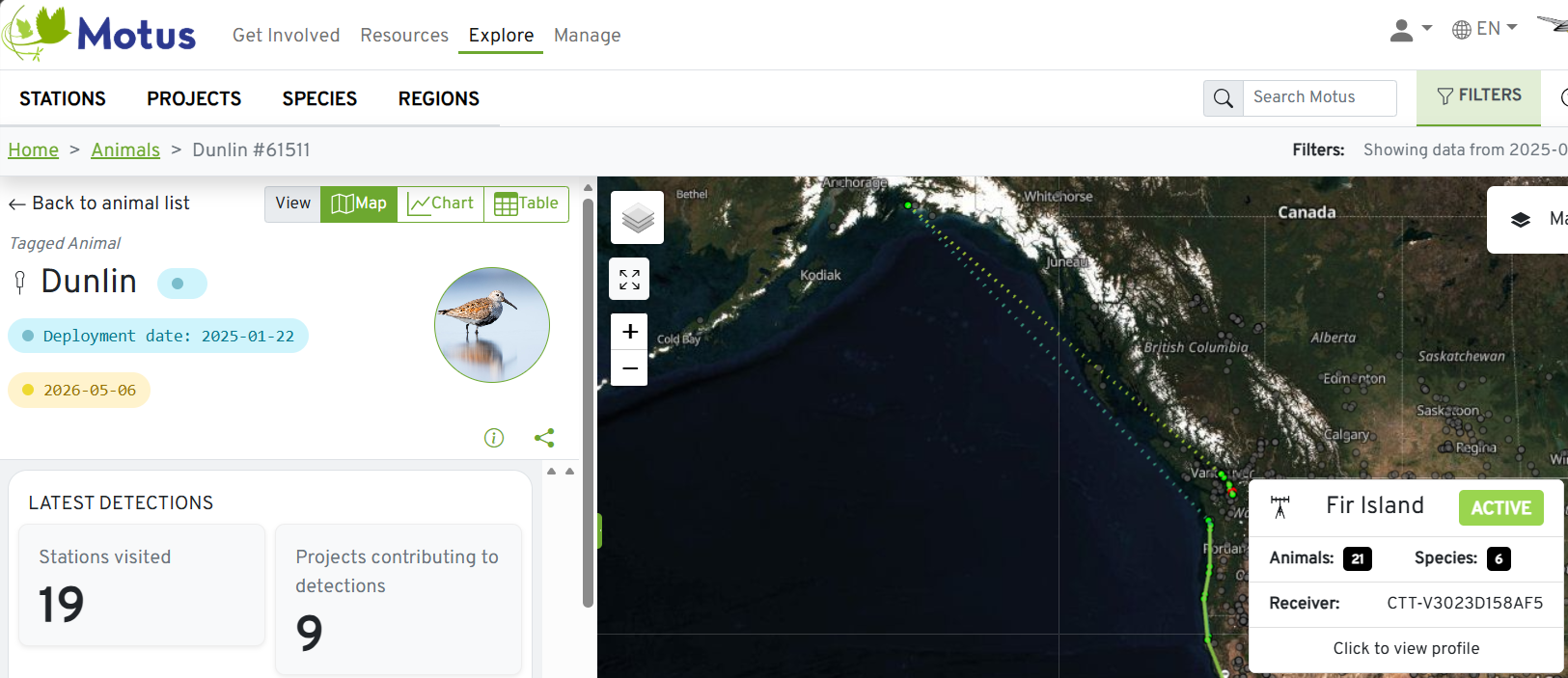 On September 5, 2026, a tagged Dunlin registered on the Fir Island Motus receiver array. By cross-referencing signal burst patterns across neighboring towers at zis a ba and Padilla Bay, researchers calculated the bird’s transit speed and exact foraging window within the estuary before it continued southward along the flyway.
These stopover metrics feed directly into restoration targets, including the multi-agency goal of restoring 2,700 acres of estuarine marsh in the Skagit Delta. As someone who helps edit and share local chapter updates, I find these concrete detections especially powerful, they turn abstract conservation goals into stories you can point to on a map.
From Tracking to Prediction
As the volume of structured telemetry grows, the next layer is modeling. Crowdsourced Motus detections, combined with satellite imagery and weather data, are being ingested into spatio-temporal models that treat the flyway as a dynamic system rather than a static map.
The Cornell Lab of Ornithology’s eBird Status and Trends project already uses machine learning on billions of observations to produce predictive “digital twins” of bird distributions across the full annual cycle. The Nature Conservancy’s BirdReturns program takes the idea further into operations: predictive models identify the exact windows when shorebirds will need temporary wetland habitat, then run a reverse-auction marketplace that pays farmers to flood fields for those two-to-four-week periods.
We have moved from knowing roughly where a bird was, to knowing what it was doing in near real time, to forecasting when it will need a particular piece of habitat. The gap between field biology and systems engineering is narrowing, and the practical result is conservation that can respond while the birds are still moving.
Looking Closer
If you want to explore the underlying data or support the work:
- BirdLife’s 2026 State of the World’s Birds interactive portal
- Mongabay’s coverage of the report and of coordinated flyway strategies
- Recent features in The Conversation on nanotag tracking and migratory-bird conservation
- The live Motus receiver map for detections across Washington and beyond
The technology is not a substitute for protecting habitat. It is a way to visualize and quantify the remaining habitats so they can be planned more precisely for the species that still depend on it. For those of us who both build systems and spend time in the field, watching the same mudflats year after year, helping local chapters tell the story, that feels like useful work.